Area Measure Length GPS, GLand

ID: com.gis.toptoshirou.landmeasure.Glandmeasure
-
Version:
Varies with device
-
Update on:
2023-02-10
Download APK now
Warranty safe installation, no addition ads or malware 


The description of Area Measure Length GPS, GLand
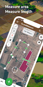
GLandMeasure is a free app for measuring areas and lengths that can be used to measure land, farm, field, home, distance, and length measurement easily. With the method of pinning on the map Or use the actual walking method Which the app will calculate the area And length automatically You can also choose from several types of measurement units. And can also be able to easily share images of the area Just a few steps
It covers the use of people who work in real estate as well. Including farmers who want to use it, it is considered an answer. After measuring the area, you can export your coordinates in a variety of formats, such as land sales announcements. Real Estate Society, PDF, Excel, KML, Geojson, map photos, route finder, elevation, soil cue calculations, tree counts in area, weather forecasts, calculations and cameras.
Support various tools compass tool convert measurement units Coordinate unit converter GEO(Lat Long) UTM MGRS Geojson geographic camera
Supports multiple layers: WMS, XYZ Tiles, Image Layers, Current Rain Layers.
Support to create multiple projects
Support for displaying large amounts of data
Show more
Featured Videos
4:19
3:17
7:12
--:--
6:06
6:27
1:49
-
Get it on:

-
Requirements:
Android Varies with device+
Area Measure Length GPS, GLand Varies with device APK for Android Varies with device+
| Version | Varies with device for Android Varies with device+ |
| Update on | 2023-02-10 |
| Installs | 1.000.000++ |
| File size | 33.778.479 bytes |
| Permissions | view permissions |
| What's new |
- ยินดีต้อนรับเข้าสู่ GLandMeasure เวอร์ชั่น 3 โฉมใหม่!!! ชุมชน - การวัดที่ดินวัดความยาวได้ง่ายขึ้นด้วยการลากจุดพิกัด - ส่งต่อ แชร์ข้อมูล ไปยังสื่อโซเชียล Facebook ,Line และอื่นๆ ยกตัวอย่างเช่นการโพสขายอสังหาริมทรัพย์ - เพิ่ม function import KML, คำนวณปริมาตรดิน , ตรวจวัดระดับความสูงของพื้นที่,คำนวณต้นไม้,พยากรณ์อากาศ ปรับแต่งการแสดงผลให้ดีมากขึ้น,เพิ่มชั้นข้อมูลภาพ - สามารถเพิ่มจุดพิกัดที่สนใจได้แล้ว - สร้างโปรเจคแยกได้แล้ว - เพิ่มกล้องในแอป - เพิ่ม GeoJson ,Geohash - bug fixes ar |
FAQs
-
Easy to use, useful app for an area, distance and perimeter management. GPS Field Area Measure is also useful as a map measurement tool for outdoor activities, range finder applications and sports such as biking or marathon. ...
-
Just navigate to the land you want to measure, click your way around the perimeter and the calculator below the map will tell you how many acres are within the perimeter you've established. Easy as that. You can also then export the area you've just drawn as a KML file and load that file onto Google Maps at any time.
-
- On your Android phone or tablet, open the Google Earth app .
- Search for a place, or select a location on the globe.
- Tap Measure .
- To add measurement points, move the map and tap Add point.
- To remove a point, at the top, tap Undo .
- When finished, at the top, tap Done. . On the bottom, you'll see the distance measurement.
-
A square metre is defined as the area that is enclosed by a square, with sides measuring 1 metre. One sq m is equal to 10.76 sq ft, and one acre is equal to 4,047 sq m....Common land measurement units used in India.
Show more
Versions history:
- 1. LATEST. Area Measure Length GPS, GLand Varies with device APK (2023-02-10, 32 MB)
- 2. Area Measure Length GPS, GLand Varies with device APK (2023-01-12, 32 MB)
- 3. Area Measure GPS GLandMeasure Varies with device APK (2023-01-01, 32 MB)
- 4. Measure area GPS GLandMeasure Varies with device APK (2022-12-25, 32 MB)
- 5. Measure area GPS GLandMeasure Varies with device APK (2022-09-06, 32 MB)
- 6. Measure area, land, measure length - GLandMeasure Varies with device APK (2022-08-24, 32 MB)
- 7. Measure area, land, measure length - GLandMeasure Varies with device APK (2022-08-16, 32 MB)
- 8. Measure area, land, measure length - GLandMeasure 3.1.7 APK (2022-07-20, 32 MB)
- 9. Measure area, land, measure length - GLandMeasure 3.1.5 APK (2022-07-16, 32 MB)
- 10. Measure area, land, measure length - GLandMeasure 3.1.3 APK (2022-07-07, 32 MB)
- 11. Measure area, land, measure length - GLandMeasure 3.1.2 APK (2022-07-03, 32 MB)
- 12. Measure area, land, measure length - GLandMeasure 2.22.1 APK (2022-06-29, 32 MB)
- 13. Measure area, land, measure length - GLandMeasure 2.21.1 APK (2022-05-20, 32 MB)
- 14. Measure area, land, measure length - GLandMeasure 2.21.0 APK (2022-05-17, 32 MB)
- 15. Measure area, land, measure length - GLandMeasure 2.21.0 APK (2022-05-07, 32 MB)
- 16. Measure area, land, measure length - GLandMeasure 2.20.1 APK (2022-05-05, 32 MB)
- 17. Measure area, land, measure length - GLandMeasure 2.20.0 APK (2022-04-26, 32 MB)
- 18. Measure area, land, measure length - GLandMeasure 2.19.1 APK (2022-04-13, 31 MB)
- 19. Measure area, land, measure length - GLandMeasure 2.19.0 APK (2022-04-13, 31 MB)
- 20. Measure area, land, measure length - GLandMeasure 2.18.9 APK (2022-03-25, 30 MB)
- 21. Measure area, land, measure length - GLandMeasure 2.18.8 APK (2022-03-07, 30 MB)
- 22. Measure area, land, measure length - GLandMeasure 2.18.7 APK (2022-02-24, 30 MB)
- 23. Measure area, land, measure length - GLandMeasure 2.18.6 APK (2022-02-19, 30 MB)
- 24. Measure area, land, measure length - GLandMeasure 2.18.5 APK (2022-01-16, 30 MB)
- 25. Measure area, land, measure length - GLandMeasure 2.18.4 APK (2022-01-15, 30 MB)
- 26. Measure area, land, measure length - GLandMeasure 2.18.2 APK (2022-01-10, 30 MB)
- 27. Measure area, land, measure length - GLandMeasure 2.18.1 APK (2022-01-09, 30 MB)
- 28. Measure area, land, measure length - GLandMeasure 2.17.7 APK (2021-10-14, 26 MB)
- 29. Measure area, land, measure length - GLandMeasure 2.17.6 APK (2021-10-10, 26 MB)
- 30. Measure area, land, measure length - GLandMeasure 2.17.5 APK (2021-09-30, 26 MB)
- 31. Measure area, land, measure length - GLandMeasure 2.17.4 APK (2021-08-19, 26 MB)
- 32. Measure area, land, measure length - GLandMeasure 2.17.3 APK (2021-08-08, 26 MB)
- 33. Measure area, land, measure length - GLandMeasure 2.17.2 APK (2021-08-05, 26 MB)
- 34. Measure area, land, measure length - GLandMeasure 2.17.1 APK (2021-07-29, 26 MB)
- 35. Measure area, land, measure length - GLandMeasure 2.16.1 APK (2021-07-22, 26 MB)
- 36. Measure area, land, measure length - GLandMeasure 2.15.2 APK (2021-07-18, 25 MB)
- 37. Measure area, land, measure length - GLandMeasure 2.15.0 APK (2021-07-08, 25 MB)
- 38. Measure area, land, measure length - GLandMeasure 2.14.0 APK (2021-06-06, 25 MB)
- 39. Measure area, land, measure length - GLandMeasure 2.13.2 APK (2021-05-30, 25 MB)
- 40. Measure area, land, measure length - GLandMeasure 2.13.0 APK (2021-05-27, 25 MB)
- 41. Measure area, land, measure length - GLandMeasure 2.12.4 APK (2021-05-06, 25 MB)
- 42. Measure area, land, measure length, GLandMeasure 2.12.2 APK (2021-04-29, 25 MB)
- 43. Measure area, land, measure length, GLandMeasure 2.12.1 APK (2021-04-26, 25 MB)
- 44. Measure area, land, measure length, GLandMeasure 2.11.2 APK (2021-04-19, 25 MB)
- 45. Measure area, land, measure length, GLandMeasure 2.10.2 APK (2021-04-16, 25 MB)
- 46. Measure area, land, measure length, GLandMeasure 2.10.1 APK (2021-04-08, 24 MB)
- 47. Measure area, land, measure length, GLandMeasure 2.10.0 APK (2021-04-04, 21 MB)
- 48. Measure area, land, measure length, GLandMeasure 2.9.1 APK (2021-03-25, 21 MB)
- 49. Measure area, land, measure length, GLandMeasure 2.9.0 APK (2021-03-21, 21 MB)
- 50. Measure area, land, measure length, GLandMeasure 2.8.0 APK (2022-07-10, 22 MB)
- 51. Measure area, land, measure length, GLandMeasure 2.7.0 APK (2021-02-20, 22 MB)
- 52. Measure area, land, measure length, GLandMeasure 2.5.1 APK (2021-02-16, 20 MB)
- 53. Measure area, land, measure length, GLandMeasure 2.4.1 APK (2021-02-01, 17 MB)
- 54. Measure area, land, measure length, GLandMeasure 2.3.4 APK (2020-12-10, 16 MB)
- 55. Measure area, land, measure length, GLandMeasure 2.3.3 APK (2020-12-06, 16 MB)
- 56. Measure area, land, measure length, GLandMeasure 2.3.2 APK (2020-12-02, 16 MB)
- 57. Measure area, land, measure length, GLandMeasure 2.3.1 APK (2020-11-23, 16 MB)
- 58. Measure area, land, measure length, GLandMeasure 2.3.0 APK (2020-11-10, 16 MB)
- 59. Measure area, land, measure length, GLandMeasure 2.2.2 APK (2020-11-03, 16 MB)
- 60. Measure area, land, measure length, GLandMeasure 2.2.1 APK (2020-11-02, 16 MB)
- 61. Measure area, land, measure length, GLandMeasure 2.2.0 APK (2022-12-01, 16 MB)
- 62. Measure area, land, measure length, GLandMeasure 2.1.1 APK (2020-10-13, 15 MB)
- 63. วัดพื้นที่ วัดที่ดิน วัดความยาว GLandMeasure 2.1.0 APK (2020-10-11, 15 MB)
- 64. วัดพื้นที่ วัดที่ดิน วัดความยาว GLandMeasure 2.0.1 APK (2020-10-11, 15 MB)
- 65. วัดพื้นที่ วัดที่ดิน วัดความยาว GLandMeasure 2.0.0 APK (2020-09-28, 22 MB)
- 66. วัดพื้นที่ วัดที่ดิน วัดความยาว GLandMeasure 1.6.9 APK (2020-03-04, 11 MB)
- 67. วัดพื้นที่ วัดที่ดิน วัดความยาว GLandMeasure 1.6.4 APK (2019-11-11, 9 MB)
- 68. วัดพื้นที่ วัดที่ดิน วัดความยาว GLandMeasure 1.6.3 APK (2019-08-01, 9 MB)
- 69. วัดพื้นที่ วัดที่ดิน วัดความยาว GLandMeasure 1.6.2 APK (2019-07-25, 9 MB)
- 70. วัดพื้นที่ วัดที่ดิน วัดความยาว GLandMeasure 1.6.0 APK (2019-06-24, 9 MB)
- 71. วัดพื้นที่ วัดที่ดิน วัดความยาว GLandMeasure 1.5.6 APK (2019-06-07, 9 MB)
- 72. วัดพื้นที่ วัดที่ดิน วัดความยาว GLandMeasure 1.5.4 APK (2019-05-30, 9 MB)
- 73. วัดพื้นที่ วัดที่ดิน วัดความยาว GLandMeasure 1.5.3 APK (2019-05-13, 9 MB)
- 74. วัดพื้นที่ วัดที่ดิน วัดความยาว GLandMeasure 1.5.2 APK (2019-04-05, 8 MB)
- 75. วัดพื้นที่ วัดที่ดิน วัดความยาว GLandMeasure 1.4.1 APK (2018-12-28, 6 MB)
- 76. วัดพื้นที่ วัดที่ดิน วัดความยาว GLandMeasure 1.3.3 APK (2018-09-18, 13 MB)
- 77. วัดพื้นที่ วัดที่ดิน วัดความยาว GLandMeasure 1.3.2 APK (2018-09-17, 13 MB)
- 78. วัดพื้นที่ วัดที่ดิน วัดความยาว GLandMeasure 1.3.1 APK (2018-06-05, 13 MB)
- 79. วัดพื้นที่ วัดที่ดิน วัดความยาว GLandMeasure 1.2.5 APK (2018-05-24, 13 MB)
- 80. วัดพื้นที่ วัดที่ดิน วัดความยาว GLandMeasure 1.2.4 APK (2018-05-24, 13 MB)
- 81. วัดพื้นที่ วัดที่ดิน วัดความยาว GLandMeasure 1.1.1 APK (2017-08-11, 12 MB)
- 82. วัดพื้นที่ วัดที่ดิน วัดความยาว GLandMeasure 1.1.0 APK (2017-07-25, 12 MB)
Show more
Similar to "Area Measure Length GPS, GLand"


Hit APK
Show more